
“O God, creator of heaven and earth, you have filled the world with beauty and abundance. Open our eyes to behold your gracious hand in all your works; that rejoicing with your whole creation, we may learn to serve you with gladness; for the sake of him through whom all things were made, your Son, Jesus Christ our Lord. ”
The Importance of Land
The Bible unfolds in a definite place, a relative narrrow band of land of Israel. And land is the basis for any agricultural society which we find in the Bible.After the Pentateuch (the first five books of Scripture), there is a major transition as the wandering Israelites entered the ancient land of Canaan. Under Joshua, the Israelite armies conquered this territory promised to them by God as an inheritance (Josh. 1:1-6). The small land of Israel, just 200 miles long and 100 miles wide, would be the main stage for stories in the Bible from then .
There are connecting points between land, life, and theology. The three great festivals (Passover, Firstfruits, and Ingathering) corresponded to the beginning and end of harvests. Rain is the grace of God. Food on the table is the blessing of God. Drought is a time of testing. The land also supported the herding of sheep and goats. So it was easy to describe God’s care as his shepherding (Ps. 23), and Jesus as “the good shepherd.” Real land, real life, real people, real God.
Land in the Bible
Most of the references of land fall into the Old Testament.
From Land (Israel)
“The Lord “cut” an unconditional covenant with Abraham in which he stated, “To your descendants I give this land, from the river of Egypt to the great river, the Euphrates” ( Gen 15:18 ). The Lord periodically reconfirmed the aspect of the land to Abraham ( Gen 12:7 ; 13:14-17 ; 17:8 ; 24:7 ). The reason the Lord gave this land to the children of Israel was because he was faithful to his covenant to Abraham ( Deut 9:4-5 ), his love for Abraham ( Deut 4:37 ), and his love for Israel ( Deut 7:8 ).
“It was only after the Lord “cut the covenant” with Abraham that he gave a general delineation of the land. He said, “To your descendants I give this land, from the river of Egypt to the great river, the Euphrates” ( Gen 15:18 ).
“A number of laws in the Book of Deuteronomy are rooted in the land: the year of release from debt ( 15:1-11 ), appointing just judges ( 16:18-20 ), selection of a king ( 17:14-20 ), abominations of the nations ( 18:9-14 ), the cities of refuge ( 19:1-13 ), removing landmarks ( 19:14 ), unknown murder ( 21:1-9 ), leaving a hanged man on a tree ( 21:22-23 ), divorce ( 24:1-4 ), and just weights and measurements ( 25:13-16
“The Bible describes the land of Israel at least nineteen times as “a land flowing with milk and honey” ( Lev 26:3-12 ; Numbers 13:23Numbers 13:28 ; 14:7 ; 24:3 ; Deut 6:3 ; 11:9 ; Deuteronomy 26:9 Deuteronomy 26:15; 27:3 ; Deuteronomy 28:2-7 Deuteronomy 28:11-12 ; 31:20 ). The image can denote a lush green land that produces an abundant and fruitful harvest. But this word picture may not be an accurate representation of the term. Isaiah used the phrase “milk and honey” to describe the devastation of the land after the Assyrians conquered it ( Isa 7:21-25 ). This seeming paradox is resolved by considering the perspective of the audience being addressed.
“The idea of plenty and abundance is partially true. When God described the land of Canaan to Moses, he used the term “milk and honey” to imply the bountifulness of the land ( Exodus 3:8 Exodus 3:17 ; 13:5 ; 33:3 ; Lev 20:24 ). When the twelve spies returned from the land of Canaan, they recounted their adventures and characterized the land as “flowing with milk and honey” ( Num 13:27 ; 14:8 ). The spies observed that cattle and goats produced more milk in areas abundant with forage. Thus, an area abundant with vegetation would be considered a land “flowing with milk.” Honey, in the biblical period, was not a cultivated product. It was associated with nonagricultural areas that were covered with wild vegetation. This is demonstrated by the account of Saul swearing his men to an oath when they fought the Philistines ( 1 Sam 14:25-26 ).
“When Israel entered the land of Canaan, the hill country was uninhabited and covered with natural forests and thickets. Joshua commanded the tribe of Joseph to go up to the forest country and clear a place. When they took the wooded area, cut it down, terraced it, and planted trees on the terracing, the Israelites passed from a pastoral society to an agricultural/farming society.
“The entire land was not uninhabited and forested. The Canaanites lived in the valleys and cultivated them ( Joshua 17:16 ). The twelve spies returning from their trip into the land of Canaan carried the bounty of the summer harvestgrapes, pomegranates, and figsfrom the cultivated Valley of Eshkol ( Num 13:23 ).
“Why is this land called the promised land? After all, life was easier in Egypt (barring the oppression of Pharaoh, of course). Every year the Nile River overflowed its banks with rich alluvial soil. The farmers also had a constant supply of water with which to irrigate their fields. Just before the children of Israel entered the land, Moses contrasted the land of Canaan with Egypt. He said, “The land you are entering to take over is not like the land of Egypt, from which you have come, where you planted your seed and irrigated it by foot as in a vegetable garden. But the land you are crossing over to take possession of is a land of mountains and valleys that drinks water rain from heaven” ( Deut 11:10-11 ). The Israelite farmer, living in the land of Israel, had to plow the soil after the early rains loosened the hard soil in the fall and had to depend on the rains throughout the winter months. If it did not rain, drought and famine resulted
“Monson observes that the purpose of the land was to serve as God’s testing ground of faith! The Lord wanted to see if his people, redeemed by his matchless grace and mighty power out of slavery in Egypt, and brought through the wilderness and into the promised land, would worship him and him alone. The tenor of the Hebrew Scriptures seems to indicate that the people of Israel were to be an agrarian society, living in dependence upon the Lord. They were not to be an international mercantile society like the Phoenicians.”
The Anatomy of Land Use in America, 2020
From The Visual Capitalist January 14, 2020 By Iman Ghos
The United States is not just an economic and political giant on the global stage—the country also has one of the largest land masses at its disposal.
Altogether, the country spans 3.8 million square miles (9.8 million km²)—making it the third largest country in the world. Even without factoring Alaska and Hawaii into the calculations, the contiguous U.S. land mass can fit up to 30 European countries within it.
With this much ground to work with, it raises the natural question of how land actually gets used by America’s economy. For example, what percentage of land is taken up by urban areas, and how much farmland and forests exist in comparison?
Today’s maps from the McHarg Center put America’s wide variety of land uses into perspective.
The Components of U.S. Land Use
As the U.S. prepares to add 100 million more people this century, the “2100 Project: An Atlas for the Green New Deal” provides a snapshot of U.S. land use (as of 2017), aimed at managing resources to support this future.
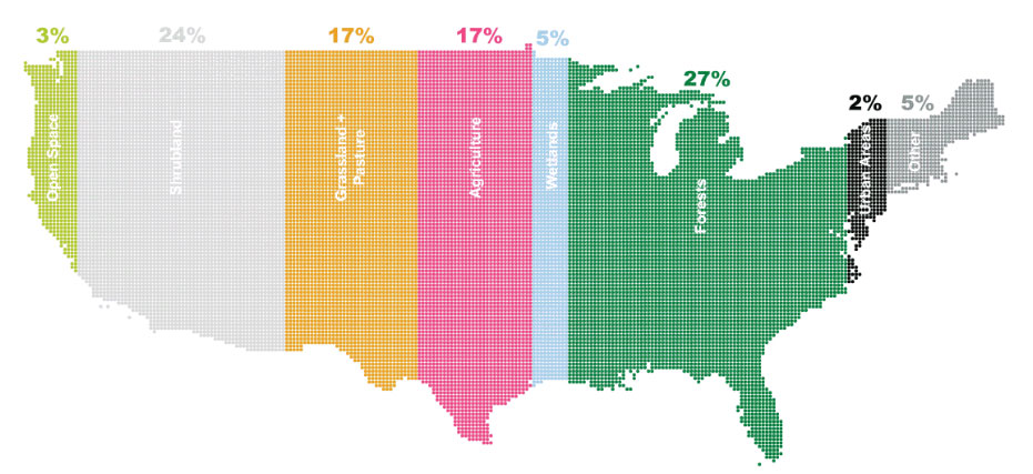
According to this data, here is a snapshot of land use in the Lower 48 States:
|
Land type |
Land use (%) |
Land area |
|
Forests |
27% |
842,400 mi² |
|
Shrubland |
24% |
748,800 mi² |
|
Agriculture |
17% |
530,400 mi² |
|
Grasslands and Pasture |
17% |
530,400 mi² |
|
Wetlands |
5% |
156,000 mi² |
|
Other |
5% |
156,000 mi² |
|
Open Space |
3% |
93,600 mi² |
|
Urban Areas |
2% |
63,400 mi² |
|
Total |
100% |
3,120,000 mi² |
These percentages have changed over time:
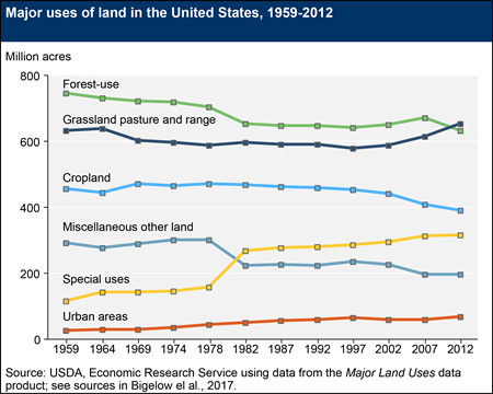
Forests and cropland have declined (in favor of grasslnds, urban area and special uses for land that includes preservation).
Let’s dive into the specifics of three types of land: urban areas, forests, and agriculture. That’s 50% of land
Small But Mighty: U.S. Urban Areas
It’s clear that even a little space goes a long way. Although urban areas take up only 2% of land, an overwhelming majority of Americans call cities their home. As of 2018, urbanites made up over 82% of the U.S. population.
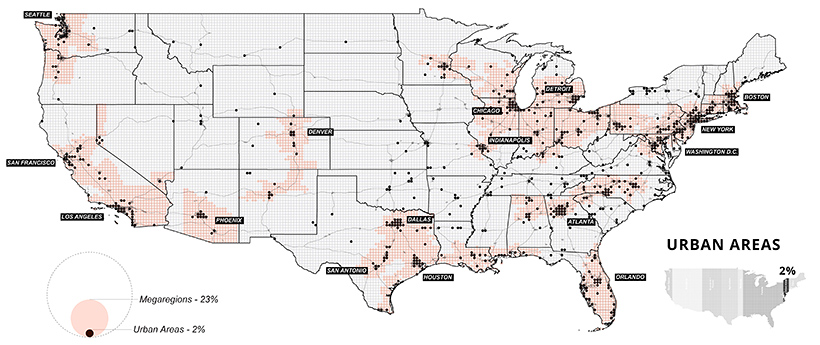
Where people go, productivity often follows. In 2018, it’s estimated that 31 county economies made up a whopping 32% of national GDP. Most of these counties were located in and around major cities, such as Los Angeles or New York.
Although urban areas are a small part of the overall land they’re built on, they’re integral to the nation’s continued growth. According to research by the McKinsey Global Institute, it’s estimated that by 2030, 60% of job growth could come from just 25 hubs
Seeing Green: America’s Vast Forests
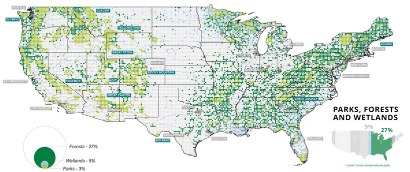
On the flipside, forests account for over a quarter of land in the U.S., divided almost evenly between deciduous and evergreen trees. Many protected national and state parks can also be found in and around forests.
On the mainland, California and Oregon are the states with the most forested land—unfortunately, they have also been plagued by wildfires in recent, dry summer months.
Wetlands are also included in the map above, particularly around the southern tip of Florida, where Everglades National Park is located. Over the years, many wetlands were drained to make way for agriculture, particularly in the Great Lakes megaregion. As a result, it’s estimated that their area today is only half of what they once used to be.
Home Grown: Agriculture in the U.S.

Last but not least, the final set of maps show where America grows its food. Agricultural, food, and related industries contributed $1.05 trillion (5.4%) to U.S. GDP in 2017.
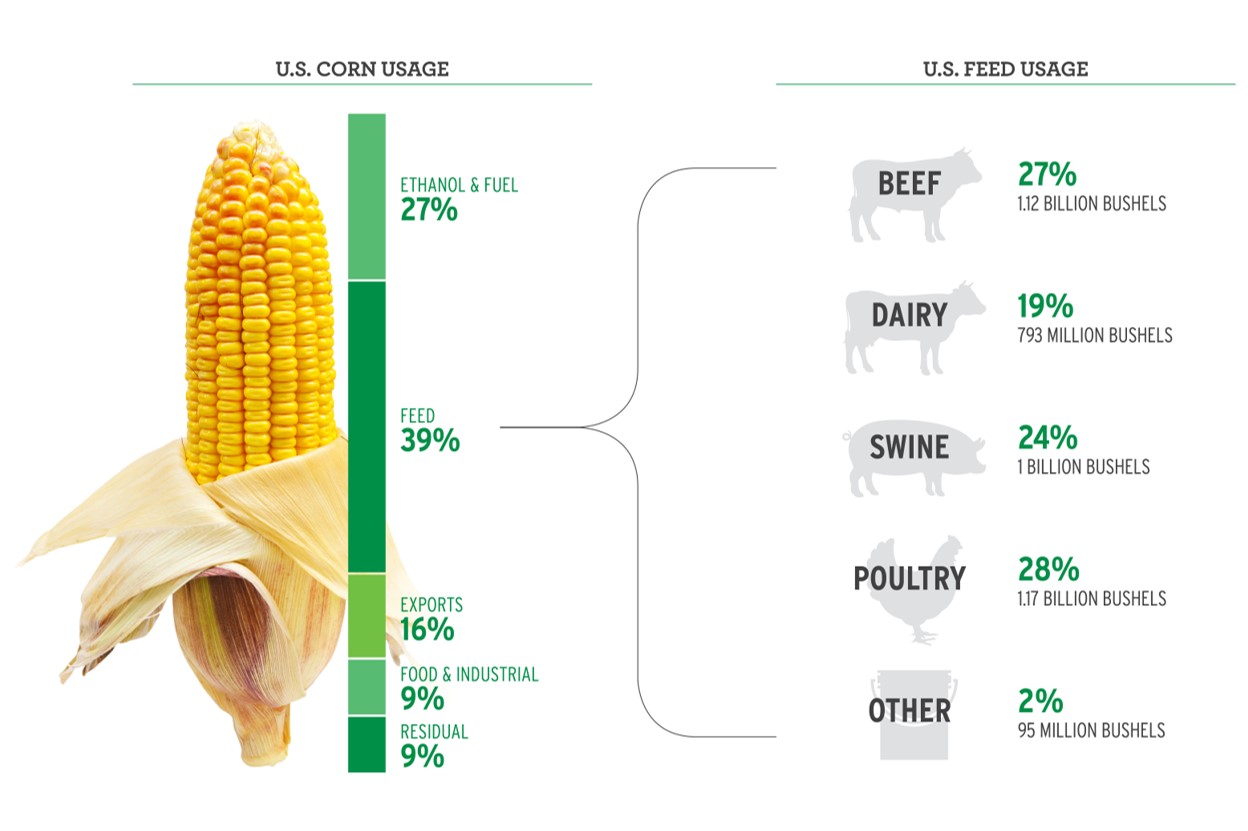
Wheat, corn, and soybeans are the major crops grown in the U.S.—and cotton also makes the cut as a profitable non-food crop. Much of these crops feed not only Americans, but other parts of the world too. Soybeans, corn, and wheat are exported across the Pacific mainly to China and Japan.
Corn, in particular, is a unique crop with a myriad of uses, from food to fuels. Up to 40% of U.S. corn is turned into livestock feed, with cows consuming over half (56%) of this amount.
At present, the U.S. is the world’s largest beef producer, followed by Brazil. In fact, beef production takes up 40% of total livestock-related land use domestically.
Although fewer American consumers are opting for meat in their diets, production has remained at high rates. Further, as incomes continues to increase worldwide, the global appetite for meat is set to rise along with it.
Future Land Use
The U.S. population is set to grow by 100 million more people over the coming decades, raising the pressure on limited U.S. land and natural resources. This pressure will be felt everywhere, from dense urban land to agricultural farmland.
How the land gets utilized will shape the country’s future for years to come
Climate Change Considerations
1. Urban
This area will be affected by rising sea levels which will affect infrastructure. Global average sea level has risen by about 7–8 inches since 1900, with almost half (about 3 inches) of that rise occurring since 1993. The urban area is affected by unequal effects of climate on poorer populations. Other effects:
A. Extreme weather: Rising global temperatures can cause more frequent and intense heatwaves, floods, droughts, and storms.
B. Infrastructure damage: Landslides, flooding, and temperature events can damage city infrastructure.
C. Water and food shortages: More people in cities are exposed to water or food shortages.
Reduced air quality: Wildfires in the West can affect air quality in nearby cities.
D. Power outages: During extreme heat, people use a lot of power to keep cool.
E. Economic impact: Climate change can have an economic impact.
Cities are especially vulnerable to climate change because they concentrate people, buildings, and infrastructure. Climate risks affect every city differently depending on their geography, and socio-economic and demographic contexts.
Some of the cities most affected by climate change in the US include:
Houston, Texas
Miami, Florida
New Orleans, Louisiana
Los Angeles, California
Memphis, Tennessee
Riverside, California
Virginia Beach, Virginia
2. Forests
Globally, some 10 million hectares of forests are lost annually, an area larger than Portugal. This deforestation drives species loss and reduces the ability of ecosystems to provide food, water, medicine, work and shelter to humans. Deforestation also causes more carbon emissions than all but two countries, and it can increase the spread of diseases, endangering human health.
Agricultural expansion, unsustainable logging and the impacts of the climate crisis are among the main drivers of deforestation globally. Halting deforestation and maintaining forests could prevent emissions of approximately 3.6 gigatons of carbon dioxide equivalent.
The restoration of 350 million hectares of deforested and degraded land by 2030 could deliver a net benefit of up to US$9 trillion, according to the Food and Agriculture Organization of the United Nations. Reforestation could cost-effectively take nearly 1.5 gigatons of carbon dioxide equivalent out of the atmosphere per year.
3. Agriculture
This area is affected by methane, as a greenhouse gas. It has a shorter life than carbon dioxide but much more powerful.
Methane is caused biologically and it comes from agriculture and our farms. One source is rice fields, but the biggest source here comes from animals especially cattle and dairy cows – cow burps.
Nitrous oxide is largely driven by fertilizer use in using manure in farms around the world. It turns out that nitrogen in fertilizers and manure sometimes combines with air and water in the soil and out gases as nitrous oxide, adding more to even climate change.
In turn, agriculture expansion affects forest deforestation adversely.
Land degradation.
Urban areas, forests and agriculture all affect the land and earth as a whole and have been affected by land degradation.
Land degradation adversely affects people’s livelihoods and occurs over a quarter of the Earth’s ice-free land area.
Land-use changes and unsustainable land management are direct human causes of land degradation with agriculture being a dominant sector driving degradation.
Forests have also been affected. Lower carbon density in re-growing forests, compared to carbon stocks before deforestation, results in net emissions from land-use change. Forest management that reduces carbon stocks of forest land also leads to emissions.
Of the land degradation processes, deforestation, increasing wildfires, degradation of peat soils, and permafrost thawing contribute most to climate change through the release of green house cassets and the reduction in land carbon sinks following deforestation.